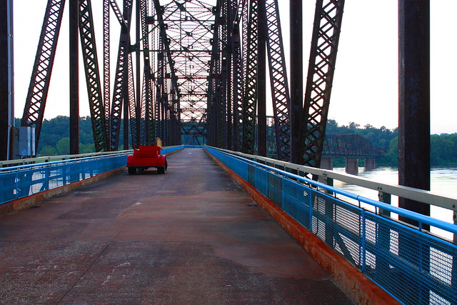
An old car sits on the deck of the old Chain of Rocks Bridge along Route 66 just north of downtown St. Louis, MO, at sunset.
Built to carry traffic across the Mississippi River and around the downtown bustle of St. Louis, MO, this bridge was the primary crossing along Route 66. A 22 degree bend in the center of the 5,353 foot span posed a continual navigational challenge for automobiles. The bend was originally designed to allow southbound riverboats to align themselves with the current, slide between the bridge’s piers, and avoid the midstream water intake towers that supply St. Louis with fresh water….quite the engineering feat for 1929.
Chain of Rocks earned it’s name from the rocky rapids that made this stretch of the Mississippi River extremely dangerous to travel. A low water dam has since been built to provide adequate depth for river traffic with the rocky shoal only partially visible, today, in low water periods.
The bend in the bridge, however, proved too be too much of an imposition for road traffic, and the bridge was permanently closed in 1967. The bridge feel into disrepair, and also became the location for several murders. Today, though, the Chain of Rocks Bridge is only open to foot and bicycle traffic thanks to the renovation of the area by a national trailway company’s efforts to preserve the site. It now serves as a monument to both modern engineering and The Mother Road, Route 66, and sits on the National Register of Historic Places.
(above text copied from my Flickr posting of the same picture)
Lovely historical place. Thanks for the info, too.
ReplyDeleteWow, you know a lot more about the bridge that I do. I've only walked across it once or twice. I knew about the murders but not that it was the river crossing for Route 66. Old Route 66 came into the city center on Watson and Chippewa or Manchester, I think, but then what streets took it up north to Chain of Rocks?
ReplyDeleteI think it may have come down Broadway. Where the intersection from CofR is I don't know. I live out in Crestwood, so Route 66 is sort of "understood" out here. I also don't know the exact routes using Lindbergh and Manchester (for instance, if 66 went through Dogtown). However, I do know Manchester from about Lindbergh out to Gray Summit (Hwy 100) was one of the Mother Road bypasses of the city of St. Louis....I want to say in the '60s.
ReplyDeleteI am slowly compiling my knowledge of Route 66 from Chain of Rocks through Missouri and the 13 mile stretch in Kansas to the Oklahoma border. I would like to travel the whole thing in sections over the next few years. (I have family in SE Kansas, which makes this pretty easy to accomplish in 30 minute jaunts.)