Showing posts with label national register of historic places missouri. Show all posts
Showing posts with label national register of historic places missouri. Show all posts
01 December 2011
From the beginning..
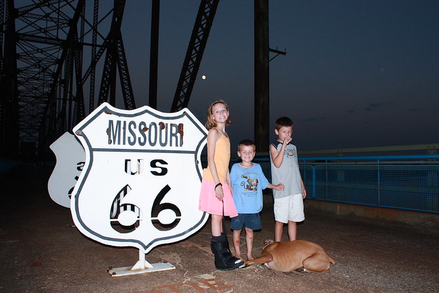
Here is a shot of Chain of Rocks, again, but from Route 66's entry point into Missouri. The Route 66 sign lies exactly on the state line between Illinois and Missouri. My kids and I...and the dog....went up one evening when mom had to work late. Not an artsy photo, just a quick snap...eyes closed and all...lol. It was getting dark, as you can see, and this isn't the best area of the city to be running around after night falls.

30 November 2011
Chain of Rocks
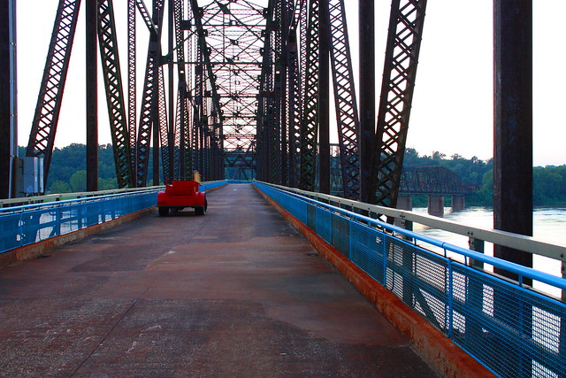
An old car sits on the deck of the old Chain of Rocks Bridge along Route 66 just north of downtown St. Louis, MO, at sunset.
Built to carry traffic across the Mississippi River and around the downtown bustle of St. Louis, MO, this bridge was the primary crossing along Route 66. A 22 degree bend in the center of the 5,353 foot span posed a continual navigational challenge for automobiles. The bend was originally designed to allow southbound riverboats to align themselves with the current, slide between the bridge’s piers, and avoid the midstream water intake towers that supply St. Louis with fresh water….quite the engineering feat for 1929.
Chain of Rocks earned it’s name from the rocky rapids that made this stretch of the Mississippi River extremely dangerous to travel. A low water dam has since been built to provide adequate depth for river traffic with the rocky shoal only partially visible, today, in low water periods.
The bend in the bridge, however, proved too be too much of an imposition for road traffic, and the bridge was permanently closed in 1967. The bridge feel into disrepair, and also became the location for several murders. Today, though, the Chain of Rocks Bridge is only open to foot and bicycle traffic thanks to the renovation of the area by a national trailway company’s efforts to preserve the site. It now serves as a monument to both modern engineering and The Mother Road, Route 66, and sits on the National Register of Historic Places.
(above text copied from my Flickr posting of the same picture)
12 November 2011
Veteran's Day at Jefferson Barracks
If you are looking for photographic opportunities, you look to places people gather. On holidays such as Memorial Day and Veteran's Day, a great place to find people can be a cemetery, especially if you live within 20 minutes of a National Cemetery like Jefferson Barracks. I drove down to capture some of the activities or scenery that caught my eye. Here comes your brief history...


A little boy plays with the United States flag as his mother and grandmother paint the lettering of a tombstone.
Selected for it's strategic position south of St. Louis, Missouri, Jefferson Barracks opened in 1826, and became the United States Army's first permanent base west of the Mississippi River. During the 1940s, it was also the largest military establishment in the country. During the Civil War, Jefferson Barracks became a training post for Union soldiers. Ironically, the cemetery also holds over 1,000 Confederate soldiers. The cemetery has honorably served as a burial place for soldiers from all US wars.

Grave markers roll with the hills as the flag in the background flies at half-staff honoring Veteran's Day.
The importance of the post waned rather quickly following World War II, and the post was deactivated in 1946. However, the grounds continue to expand as a national cemetery as demand grows. Jefferson Barracks was named to the National Register of Historical Places in 1998.

One marker is flanked by both the US flag and a flag commemorating Veteran's Day.
14 October 2011
Back to Missouri Botanical..

If you remember back to the View from the Observatory post, you remember there were some Victorian Gardens near Henry Shaw's Tower Grove House. This is a sample of what you will find. Although, this curved design was at the base of the observatory, it's very similar to what you will find in the Victorian Gardens nearer the house. The lighting was pretty poor over that way since the sun was shining directly on some bright flowers...making proper exposure difficult at best. Enjoy this well-manicured design. In the Missouri Botancial Gardens, perfect gardens like this are all around you. What a place to visit!
04 October 2011
Let's Take a Walk..
Let's meander around the Missouri Botanical Gardens in St. Louis, MO, shall we? I ran out there last week. I try and get out there once per season to see all the beautiful plants evolve through the seasons.
For today, let me give you the view from atop the observatory near Tower Grove House..

Henry Shaw lived in this "country home" on the left as he built his gardens. The building on the right is the research library. You can also see the Victorian Garden between the house and library. The garden was opened to the public in 1859 at no charge. Several years later, Shaw had this observatory built for the public to offer a better view of the land. Apparetly, Shaw grew tired of the patrons' requests to climb the tower in HIS house to view the gardens from several stories up. Can't say I blame him, either.
For today, let me give you the view from atop the observatory near Tower Grove House..

Henry Shaw lived in this "country home" on the left as he built his gardens. The building on the right is the research library. You can also see the Victorian Garden between the house and library. The garden was opened to the public in 1859 at no charge. Several years later, Shaw had this observatory built for the public to offer a better view of the land. Apparetly, Shaw grew tired of the patrons' requests to climb the tower in HIS house to view the gardens from several stories up. Can't say I blame him, either.
03 October 2011
Monday Mystery..
Where in St. Louis am I?

In answering last Monday's Mystery, I was at the top of Art Hill in Forest Park. The statue was the backside of the horse carrying King Louis IX, the city's namesake.
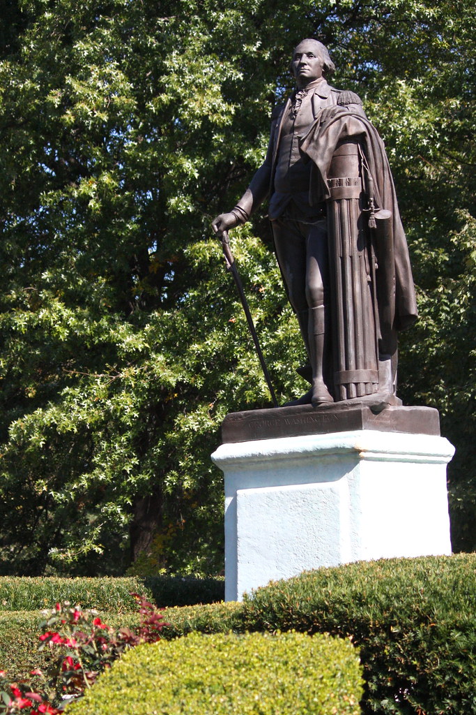
In answering last Monday's Mystery, I was at the top of Art Hill in Forest Park. The statue was the backside of the horse carrying King Louis IX, the city's namesake.
21 September 2011
Painted Ladies..

"Painted Ladies" is a term used to describe Victorian or Edwardian style homes painted in 3 different colors (usually bright colors) to accentuate the architecture. The most famous "row" of painted ladies resides in San Francisco; however, St. Louis' Lafayette Square can certainly hold it's own (pictured above). These are located on Hickory St. just north of Lafayette Park. You may also find such homes in Baltimore, MD, Cape May, NJ, New Orleans, LA, and Cincinnati, OH.
Lafayette Square is one of my favorite neighborhoods in all of St. Louis, MO. You can expect to see and learn more about this neighborhood in the future.

20 September 2011
Compton Hill Water Tower

Before modern electrical production methods, steam-driven pumps were used to send water throughout the city. The steam was powered in a 22 mile loop around downtown St. Louis originating in the Ashley Power Plant at the edge of the Mississippi River just north of Laclede's Landing. The steam often caused large surges in pressure, often causing pipes to rattle and shake. This pressure also caused multi-story buildings to have low, or no, water pressure in the higher floors. These standpipes were erected to equalize the water pressure. For aestetic purposes, towers were built to hide these standpipes.

At the peak of their use, nearly 500 of these towers dotted cities across the USA. Most were torn down as their usefullness became outdated. As of this writing, only 7 remain....three of which are in St. Louis, MO. And, each has been listed on the National Register of Historic Places since the early 1970s. The Grand, The Bissel, and the Compton Hill Water Towers were built in respective order.
Yesterday, I drove to the base of the Compton Hill Water Tower, the city's "newest." It was built in 1898 and stands 179 feet tall. The cost, then, was $48,000. The tower was taken out of service in 1929. Up to 1984, you could climb a spiral staircase inside to the top and grab a 360 degree view of the city of St. Louis. This standpipe was part of the equalization of water pressure process, but it was also necessary because of the Compton Hill Resevoir located very near the standpipe's location.
The Compton Hill Resevoir was built to provide an adequate supply of water to Tower Grove Park. This park was built and donated by Henry Shaw, one of the city's most influential millionaires of the 19th century. Like other areas of the city, follow this blog for long and you will learn about Tower Grove Park and Missouri Botanical Gardens, both Shaw creations.
In 1995, a project was started to renovate the tower and surrounding park. The renovation was completed in 1999. Occasionally, the tower is opened during neighborhood house tours so visitors can take in the views. For scheduled tours, visit the Water Tower and Park Preservation Society's Calendar (calendar).

The above photo was taken from a puddle reflection in the resevoir area. For further information check the Compton Heights Neighborhood page.
18 September 2011
9/11 Tribute..

Another viewpoint of the 9/11 Memorial in St. Louis, MO. Image taken from across the Grand Basin in Forest Park. (Image at ISO100, f/11, 1/60th with the 55-250mm lens)
17 September 2011
Approaching Autumn..

One of my favorite late summer visits is the Tower Grove Lily Ponds. This must not have been a good year for lillies because very little was happening in the park (or maybe I was a little late this year). Last year was much better. Maybe I'll post some of those images down the road. (Image shot using ISO400, f/6.3, 1/400 and my 55-250mm lens)
16 September 2011
Kicking Things Off..
I hope to avoid becoming my long-winded self in this blog. It will be a St. Louis photo blog primarily. I would like to keep things to a picture, or four, and captions 95% of the time....maybe a little about the location/image if it's important enough. This is something I have been thinking about for a long time, and I would like to chronicle St. Louis in photos and in a blog format. Saint Louis is rich in history and architecture. So, you can expect to see a lot of photos of buildings on this photo blog. Hopefully, you will learn something about our city as you follow along.

The St. Louis Art Museum forms the backdrop for one of the neatest things this city has done in a long time. The community has drawn together to honor the victims of the World Trade Center attacks of September 11th, 2001. Just under 3,000 flags have been placed across Art Hill in Forest Park, each one representing a person killed in the attacks. Each flag is placed 10 feet apart from any other flag demarking the 10th anniversary of the WTC collapse. Each flag also has a picture and name on the pole. Many St. Louisans, and likely tourists, have taken in this awesome sight over the past week. It is an honor for this to be the inagural post in my St. Louis photo blog. (Image shot at ISO100, f/11, 1/100th using Canon Rebel XSi and 55-250mm lens)

The St. Louis Art Museum forms the backdrop for one of the neatest things this city has done in a long time. The community has drawn together to honor the victims of the World Trade Center attacks of September 11th, 2001. Just under 3,000 flags have been placed across Art Hill in Forest Park, each one representing a person killed in the attacks. Each flag is placed 10 feet apart from any other flag demarking the 10th anniversary of the WTC collapse. Each flag also has a picture and name on the pole. Many St. Louisans, and likely tourists, have taken in this awesome sight over the past week. It is an honor for this to be the inagural post in my St. Louis photo blog. (Image shot at ISO100, f/11, 1/100th using Canon Rebel XSi and 55-250mm lens)
Subscribe to:
Posts (Atom)